
How to read a Georgia oversize permit
A Georgia single trip permit is three pages: permit details and travel rules on page 1, the driver signature on page 2, and the turn-by-turn route table on page 3. Page 1 has a one-line 'Route of Travel', but the miles and exits are only in the page 3 table, where distance and time add up as you go.
Issued by the Georgia Department of Public Safety, Oversize Permit Unit through GAPROS (Georgia Permitting & Routing Optimization System). Written from a real permit we read.
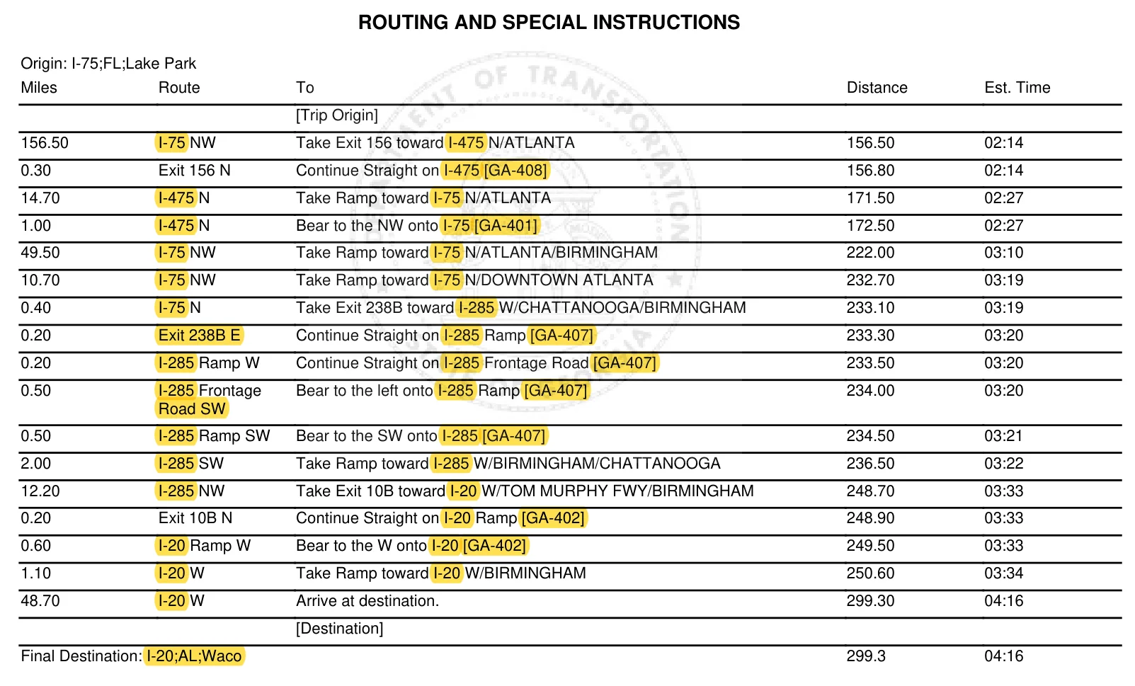
How to read the route
Read the table top to bottom. 'Route' is the road and direction you are on, like 'I-75 NW'. 'Miles' is how far you stay on it, and 'To' is the next move, like 'Take Exit 238B toward I-285 W/CHATTANOOGA/BIRMINGHAM'. 'Distance' and 'Est. Time' are running totals from the start, so the last row shows the whole trip: 299.30 miles and 04:16. The first row is long because it covers everything from the Florida line to the first exit: 156.50 miles on I-75.
Columns, left to right: Miles · Route · To · Distance · Est. Time.
What's on each page
- Page 1: Permit information: who it is issued to, valid dates, load, tractor and trailer plates, size and weight, Origin, Destination and a one-line Route of Travel. Below that: Special Circumstances, travel rules and road closure alerts.
- Page 2: General conditions, then the driver signature and date lines.
- Page 3: Routing and Special Instructions: the turn-by-turn route table, from [Trip Origin] to Final Destination.
Road names on Georgia permits
| On the permit | Means |
|---|---|
| I-75 NW | Interstate 75, heading northwest |
| I-285 SW | Interstate 285, heading southwest |
| [GA-401] | Georgia State Route 401, the state's own number for I-75 (on this permit I-475 is [GA-408], I-285 is [GA-407] and I-20 is [GA-402]) |
| Exit 238B E | The exit ramp at Exit 238B, written in the Route column as if it were a road |
| I-285 Frontage Road SW | The frontage road beside I-285, heading southwest |
| I-20;AL;Waco | I-20 at the Alabama state line, near Waco |
Where the route starts and ends
Each end is written as road;neighboring state;nearest Georgia town, split by semicolons: 'I-75;FL;Lake Park' is I-75 at the Florida line near Lake Park, and 'I-20;AL;Waco' is I-20 at the Alabama line near Waco. Page 1 lists them as Origin and Destination and wraps them in arrows in the Route of Travel line. In the page 3 table they show as [Trip Origin] and [Destination], and the line under the table repeats the end as 'Final Destination:'.
Conditions to watch for
Travel time
Daylight only: from 30 minutes after sunrise to 30 minutes before sunset.
“Travel allowed on all authorized highways and roads during daylight hours 30 minutes after sunrise and 30 minutes before sunset only.”
Weather and holidays
No travel in bad weather or on holidays. The permit points to Department Rule 672-2-.03 for what counts.
“No permitted load is authorized to travel during inclement weather and holidays as defined in Department Rule 672-2-.03. (c)”
Weigh stations
Stop at every weigh station, even if you have a bypass transponder.
“ALL PERMITTED LOADS WITH OR WITHOUT TRANSPONDERS MUST STOP AT EVERY WEIGHT STATION.”
Lane closures on set dates
Our permit listed I-285 lane closures on two weekends. On those dates, loads over 15'6" tall had to resubmit and route around them; loads 15'6" or lower could follow the signed detour.
“IF YOUR HEIGHT IS LESS THAN OR EQUAL TO 15-6" YOU ARE PERMITTED TO FOLLOW THE SIGNED DETOUR”
Escorts
The permit does not spell out escorts. It points to GDOT Rule 672-2-.06 for escorts and Rule 672-2-.03(i) for reporting accidents.
“Refer to GDOT Rule 672-2-.06 for escort requirements”
Sign it and keep it in the truck
The driver signs the permit, and the signed permit stays in the truck, ready for inspection.
“The signed permit must be in the vehicle transporting the load and shall be available at all times for inspection”
Easy to miss
- Page 1's 'Route of Travel' is only a string of roads and exits with no miles. Use the page 3 table for distances and exit numbers.
- 'Distance' and 'Est. Time' are running totals, not the miles or time for that row. Look at 'Miles' for the length of each stretch.
- The Route column sometimes names an exit, not a road: 'Exit 156 N', 'Exit 238B E', 'Exit 10B N'. Numbers in brackets like [GA-407] are Georgia's own route numbers for the same interstate, not a separate road.
- Check the Special Circumstances box on page 1 against your travel days. Our permit listed I-285 lane closures on two weekends, with different rules for loads over 15'6" tall.
Questions
What are the travel hours for an oversize load in Georgia?
Our permit allows travel only in daylight, from 30 minutes after sunrise to 30 minutes before sunset. It also says no permitted load may travel in inclement weather or on holidays as defined in Department Rule 672-2-.03.
Does a Georgia oversize permit need the driver's signature?
Page 2 says the permit must be signed by the driver and is not valid without the original signature. Page 1 adds that a driver's signature or acceptance of the electronic attest statement counts as acknowledging the requirements.
Do I have to stop at weigh stations with a Georgia oversize permit?
Yes. The permit says all permitted loads, with or without transponders, must stop at every weigh station.
Your permit is the legal document; follow everything it says. Permits change, and yours may differ from the ones we read.Last checked October 2026.